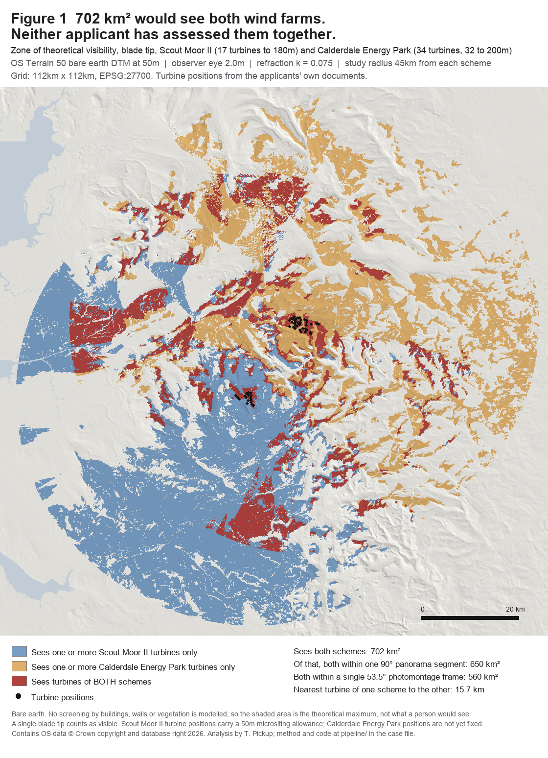
There are two wind farms proposed on the South Pennine moors, one on the Rossendale and Rochdale boundary and one above Hebden Bridge. Between them they are 51 turbines. Their nearest machines stand 15.7 kilometres apart.
Neither applicant has published an assessment of what they look like together. There is no map of it in either applicant’s documents, and there was none anywhere in the public domain. So I built one, and today I objected to both Scout Moor II applications and asked Rossendale and Rochdale to require that assessment before either council decides.
The two schemes
Scout Moor II is 17 turbines at up to 180 metres to blade tip, on the moor between Rossendale and Rochdale, next to the existing Scout Moor wind farm of 26 turbines at 100 metres. It is with both councils now, references 2025/0267 and 25/00680/FUL, and it has been undetermined since the deadline passed in November 2025.
Calderdale Energy Park is up to 34 turbines on Walshaw Moor above Hebden Bridge, 32 of them at 200 metres. It is a national infrastructure project, so the Secretary of State decides it, and the application is expected in November 2026.
Why they were never assessed together
This is not a conspiracy and I am not going to pretend it is one.
Scout Moor II’s environmental statement did search for other wind farms. It searched out to 45 kilometres, it searched the Planning Inspectorate’s register, and it assessed 22 other schemes, twelve of which are further away than Calderdale Energy Park is. What it did was set its cut-off date at February 2025.
Calderdale Energy Park reached the Planning Inspectorate’s register on 1 September 2025, seven months later. So it appears nowhere in the assessment, nowhere in the cumulative chapter, and on none of the cumulative figures. The applicant did nothing wrong in 2025. The problem is what the councils are being asked to decide on in 2026.
The gap runs both ways. The Secretary of State’s scoping opinion for Calderdale Energy Park runs to 778 pages and does not mention Scout Moor II once.
And nobody has flagged it. I have read all 41 consultee responses on the Rossendale file. Not one of them mentions Walshaw Moor or Calderdale Energy Park.
The map that did not exist
I modelled both schemes on the same terrain grid, using every turbine coordinate exactly as the applicants published it: Scout Moor II from Chapter 4 of its environmental statement, Calderdale from Table 4-1 of its preliminary environmental information report. The terrain is Ordnance Survey Terrain 50, the national bare earth model. Observer eye height 2 metres and refraction 0.075, which is standard UK practice.
Read those figures for what they are. This is a bare earth model, so it takes no account of screening by buildings, walls or trees, and a single visible blade tip counts as visible. It is the theoretical maximum, not what a person standing there would see. That is the same basis both applicants use for their own visibility maps, which is the point of using it.
I also checked it against the applicants’ own work. Calderdale’s Table 12-9 lists 23 settlements where it predicts no visibility at all. Twenty-two of those are in the national gazetteer, and at all twenty-two my model also returns zero. Where my model and theirs disagree, and at a few places to the west they do, the objection uses their figure and says so.
Why it matters legally
Rossendale’s adopted Local Plan, Policy ENV7, supports a commercial wind farm only if a list of criteria is met to the council’s satisfaction. One of them is that the proposal:
would not result in unacceptable visual clutter in combination with other existing structures, with cumulative impacts fully assessed to the satisfaction of the Council
The plan’s own explanation, at paragraph 262, says why that criterion is there: “In parts of the Borough there has been cumulative visual impact, including with adjacent schemes outside Rossendale. Different heights and designs of turbine can have discordant visual effects.”
That is precisely this case. Calderdale Energy Park is an adjacent scheme outside Rossendale, and it is a different height and a different design: 200 metres against this application’s 180.
There is a second problem, and it is the one I would put first. Regulation 26(2) of the environmental impact assessment rules says a council must not grant permission unless it is satisfied that its reasoned conclusion on significant effects “is up to date”. A cumulative chapter that stopped looking in February 2025 is not an up to date conclusion in August 2026.
What I have asked for
I have not asked either council to refuse. I have asked them to require further information under Regulation 25 before they decide, covering the cumulative landscape and visual effects of the two schemes together, and to agree the viewpoints in advance and publish them. Whoever chooses the viewpoints decides what such an assessment is capable of finding.
It is not a big ask, and it is not a new one. Natural England has already told the council, in a response headed “FURTHER INFORMATION REQUIRED”, that it needs more before it can advise, and asked to be re-consulted when it arrives. The councils’ own commissioned reviewer, JBA Consulting, recommended further information in May. There is already a further information exercise running. I have asked that it cover the one topic where the environmental statement admits significant harm, and where no independent review has been commissioned at all.
Read it yourself
The objection runs to 17 pages, with a method note and a list of every settlement in the overlap. Every legal citation in it has been checked against the primary source, and where I got something wrong in an earlier draft I have said so in the document rather than quietly fix it.
Submitted to Rossendale Borough Council and Rochdale Borough Council on 24 August 2026, copied to the Planning Casework Unit at the Ministry of Housing, Communities and Local Government.
If you want to object yourself, the references are 2025/0267 at Rossendale and 25/00680/FUL at Rochdale. Rossendale takes comments at planning@rossendalebc.gov.uk and Rochdale at development.management@rochdale.gov.uk. Say which application you are commenting on, and ask for it to be logged on both.
Method and sources
Turbine positions are taken from Scout Moor II environmental statement Chapter 4 Table 4.1 and Calderdale Energy Park preliminary environmental information report Table 4-1, and were checked line by line against those tables. Terrain is OS Terrain 50, the Ordnance Survey national bare earth model, under the Open Government Licence. Settlement points are from OS Open Names. The grid is 112km by 112km at 50 metre cells, observer eye height 2.0 metres, refraction coefficient 0.075, study radius 45 kilometres from each scheme, visibility judged on blade tip. Scout Moor II positions carry the 50 metre micrositing allowance stated in the environmental statement, and Calderdale Energy Park’s positions are not yet fixed. Policy text is from the Rossendale Local Plan 2019 to 2036, adopted 15 December 2021. The regulations cited are the Town and Country Planning (Environmental Impact Assessment) Regulations 2017. Contains OS data © Crown copyright and database right 2026.
This objection is made in a personal capacity and as county councillor for Padiham and Burnley West. It is not made on behalf of Lancashire County Council and does not represent the county council’s position.